Official Name:
青山岭长城4段QingShanLingChangCheng4DuanOur Name:
/
Other Name:
/
Period:明 / Ming Dynasty 1368~1644
Location: 天津市,天津市,蓟县,下营镇青山岭长城3段山险止点 / TianJinShi,TianJinShi,JiXian,XiaYingZhenQingShanLingChangCheng3DuanShanXianZhiDian
[
Looking Local List]
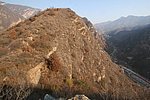
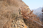
Details:长城类别:墙体
起点经纬高度:东经:117° 29′ 北纬:40° 12′ 海拔:509
终点经纬高度:东经:117° 29′ 北纬:40° 12′ 海拔:513
墙体走向:此段长城墙体自青山岭长城3段山险起,向北沿山脊修建,至青山岭5段山险起点截止,走向由南至北。
墙体类别:石墙
结构特点及构筑方式:该段长城采用毛石干垒而成。
垒砌方法:
墙体的垒砌方法与以往的墙体基本相同,也是墙体的内外两侧均采用较大的石块垒砌成两道外墙体,然后再这两道墙体缝隙中间填充相对小的石块和碎石片,形成完整的墙体。此段长城石块之间未用泥土、白灰等粘结物。
现状:此段长城为石墙。此段长城墙体保存一般,全长28米。
起点坐标:东经:117°29′57.36″北纬:40°12′23.64″高程:509米,
止点坐标:东经:117°29′57.66″北纬:40°12′24.36″高程:513米。
Type:石墙 Stone wall
Protection Level:省保
Content:
Memo:
Other Records:
Distribution:
visit location in Tianditu Map[recommend] Distribution:
visit location in Tencent QQ Map Distribution:
visit location in Google MapDistribution:
visit location in Baidu MapNational ID:120225382102170091
Action:[
 Save in Data Basket
 ]
Picture:
Click the thumbnail to view the Big Pic. Click the Big Pic to Hide the Big Pic![Caption:青山岭长城4段
loading images --Please wait...]()
![Caption:青山岭长城4段
loading images --Please wait...]() Photo Links
Photo Links:
 Search ::
  Favorite/My Favorite :: Recent Changes :: :: Login