Official Name:
下脖项长城1段XiaBoXiangChangCheng1DuanOur Name:
山险 / ShanXian
Other Name:
/
Period:明 / Ming Dynasty 1368~1644
Location: 青海省,西宁市,湟源县,起点:东峡乡下脖项村六社西南0.5千米处的山梁上止点:东峡乡下脖项村六社西北0.18千米处的山坡上 / QingHaiSheng,XiNingShi,YuanXian,QiDianDongXiaXiangXiaBoXiangCunLiuSheXiNan05QianMiChuDeShanLiangShangZhiDianDongXiaXiangXiaBoXiangCunLiuSheXiBei018QianMiChuDeShanPoShang
[
Looking Local List]
Details:长城类别:墙体
起点经纬高度:东经:101° 25′ 北纬:36° 39′ 海拔:2625
终点经纬高度:东经:101° 25′ 北纬:36° 40′ 海拔:2472
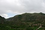
墙体走向:该段山险先呈东南-西北向沿陡坡顶部延伸至GPS0533点,又转为西南-东北向沿山嘴而下穿过下脖项关直至山根。
墙体类别:山险
结构特点及构筑方式:此段山险山高坡陡,是不易逾越的天然屏障。无。
现状:山险。
Type:山险 Precipitous mountain areas
Protection Level:无
Content:
Memo:
Other Records:
Distribution:
visit location in Tianditu Map[recommend] Distribution:
visit location in Tencent QQ Map Distribution:
visit location in Google MapDistribution:
visit location in Baidu MapNational ID:630123382106170001
Action:[
 Save in Data Basket
 ]
Picture:
Click the thumbnail to view the Big Pic. Click the Big Pic to Hide the Big Pic![Caption:下脖项长城1段
loading images --Please wait...]()
![Caption:下脖项长城1段
loading images --Please wait...]()
![Caption:下脖项长城1段
loading images --Please wait...]() Photo Links
Photo Links:
 Search ::
  Favorite/My Favorite :: Recent Changes :: :: Login