Official Name:
河西堡―金川峡山险HeXiBaoJinChuanXiaShanXianOur Name:
/
Other Name:
/
Period:明
/ Ming Dynasty 1368~1644
Location: 甘肃省,金昌市,永昌县,起点:河西镇原河西堡铁厂、水泥厂西侧1千米处红山顶止点:城关镇金川峡水库大坝西北侧360米处(金川峡之河西堡道路西侧)山腰处 / GanSuSheng,JinChangShi,YongChangXian,QiDianHeXiZhenYuanHeXiBaoTieChangShuiNiChangXiCe1QianMiChuHongShanDingZhiDianChengGuanZhenJinChuanXiaShuiKuDaBaXiBeiCe360MiChu(JinChuanXiaZhiHeXiBaoDaoLuXiCe)ShanYaoChu
[
Looking Local List]
Details:长城类别:墙体
起点经纬高度:东经:102° 02′ 北纬:38° 21′ 海拔:1902
终点经纬高度:东经:102° 00′ 北纬:38° 20′ 海拔:1905
墙体走向:总体走向由东北向西南方向延伸。
墙体类别及构筑方式:以悬崖峭壁为天然阻挡,天然形成。
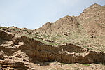
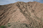
墙体类别:山险
结构特点及构筑方式:无。以山为险。保存一般。山险沿红山、黑石头沟顶,经过营盘顶、宝塔沟、马家大沙沟,西至原金川峡水库管理所以西约300米处,南距金川峡水库大坝约400米的山腰间,与金川西壕堑相衔接。
山险海拔在1792-1902米之间,中部最高处海拔2367米,地处营盘山的中部,山峦叠嶂,群峰连绵,岩石裸露,坡陡崎岖险要,山势陡峭峻拔,巍峨磅礴,难以攀爬,是长城防御体系中难以逾越的天然屏障。
现状:
Type:山险 Precipitous mountain areas
Protection Level:
Content:
Memo:
Other Records:
Distribution:
visit location in Tianditu Map[recommend] Distribution:
visit location in Tencent QQ Map Distribution:
visit location in Google MapDistribution:
visit location in Baidu MapNational ID:620321382106170040
Action:[
 Save in Data Basket
 ]
Picture:
Click the thumbnail to view the Big Pic. Click the Big Pic to Hide the Big Pic![Caption:河西堡―金川峡山险
loading images --Please wait...]()
![Caption:河西堡―金川峡山险
loading images --Please wait...]() Photo Links
Photo Links:
 Search ::
  Favorite/My Favorite :: Recent Changes :: :: Login