Official Name:
小口山险1段XiaoKouShanXian1DuanOur Name:
/
Other Name:
/
Period:明
/ Ming Dynasty 1368~1644
Location: 甘肃省,白银市,靖远县,起点:石门乡小口村西北3千米胡麻沟口西南侧止点:石门乡小口村南700米青崖沟口(也叫大口子) / GanSuSheng,BaiYinShi,JingYuanXian,QiDianShiMenXiangXiaoKouCunXiBei3QianMiHuMaGouKouXiNanCeZhiDianShiMenXiangXiaoKouCunNan700MiQingYaGouKou(YeJiaoDaKouZi)
[
Looking Local List]
Details:长城类别:墙体
起点经纬高度:东经:104° 16′ 北纬:37° 04′ 海拔:1332
终点经纬高度:东经:104° 18′ 北纬:37° 02′ 海拔:1332
墙体走向:以黄河南岸分布的高山为主线,总体为西北-东南走向。
墙体类别:山险
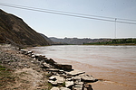
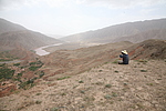
结构特点及构筑方式:该段山险为陡峭的黄河南岸的高山,立面坡度在65°-85°之间,并以滔滔的黄河天险为总体防御体系。
该段山险起自第0067点,止于第0070点,全长4877米。
这段山险以黄河南岸的两座高山崖壁和汹涌的黄河做为防御的体系,南依连绵的山脉,北临黄河,河面宽约150米-300米,深50米-80米,最高点小口1号烽火台海拔1564米,与黄河河面的相对高度在250米-350米,加之有黄河的阻隔,长城利用了这一天然的屏障,将敌人阻于黄河以北,在山顶的制高点上建烽火台,用于传递信息。
与相邻墙体和其他相关遗存的平面位置关系:西北与胡麻沟外长城相接,经小口1号烽火台、小口2号烽火台,东南与小口长城1段连接。
现状:
Type:山险 Precipitous mountain areas
Protection Level:
Content:
Memo:
Other Records:
Distribution:
visit location in Tianditu Map[recommend] Distribution:
visit location in Tencent QQ Map Distribution:
visit location in Google MapDistribution:
visit location in Baidu MapNational ID:620421382106170015
Action:[
 Save in Data Basket
 ]
Picture:
Click the thumbnail to view the Big Pic. Click the Big Pic to Hide the Big Pic![Caption:小口山险1段
loading images --Please wait...]()
![Caption:小口山险1段
loading images --Please wait...]() Photo Links
Photo Links:
 Search ::
  Favorite/My Favorite :: Recent Changes :: :: Login