Official Name:
清水川河险QingShuiChuanHeXianOur Name:
/
Other Name:
/
Period:明 / Ming Dynasty 1368~1644
Location: 陕西省,榆林市,府谷县,起点:清水乡转角楼村北150米止点:清水乡凤凰塔村西500米 / ShanXiSheng,YuLinShi,FuGuXian,QiDianQingShuiXiangZhuanJiaoLouCunBei150MiZhiDianQingShuiXiangFengHuangTaCunXi500Mi
[
Looking Local List]
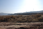
Details:长城类别:墙体
起点经纬高度:东经:111° 1′ 北纬:39° 19′ 海拔:1014
终点经纬高度:东经:111° 1′ 北纬:39° 19′ 海拔:953
墙体走向:西北-东南
墙体类别:河险
结构特点及构筑方式:无。自然冲刷形成的宽阔的河床。
现状:河险。
Type:河险 Precipitous river
Protection Level:无
Content:
Memo:
Other Records:
Distribution:
visit location in Tianditu Map[recommend] Distribution:
visit location in Tencent QQ Map Distribution:
visit location in Google MapDistribution:
visit location in Baidu MapNational ID:610822382107170011
Action:[
 Save in Data Basket
 ]
Picture:
Click the thumbnail to view the Big Pic. Click the Big Pic to Hide the Big Pic![Caption:清水川河险
loading images --Please wait...]() Photo Links
Photo Links:
 Search ::
  Favorite/My Favorite :: Recent Changes :: :: Login