Official Name:
ЙЋУэГЄГЧ11ЖЮGongMiaoChangCheng11DuanOur Name:
/
Other Name:
/
Period:еНЙњед / Warring States 475~221 B.C.
Location: ФкУЩЙХзджЮЧј,АЭбхФзЖћЪа,ЮкРЬиЧАЦь,Ц№ЕуЃКАзбхЛЈеђЙЋУэааеўДх15.8ЧЇУзжЙЕуЃКАзбхЛЈеђЙЋУэааеўДх16.5ЧЇУз / NeiMengGuZiZhiQu,BaYanNaoErShi,WuLaTeQianQi,QiDianBaiYanHuaZhenGongMiaoXingZhengCun158QianMiZhiDianBaiYanHuaZhenGongMiaoXingZhengCun165QianMi
ЁЁ[
Looking Local List]
Details:ГЄГЧРрБ№ЃКЧНЬх
Ц№ЕуОЮГИпЖШЃКЖЋОЃК108Ёу 54Ёф ББЮГЃК40Ёу 38Ёф КЃАЮЃК1072
жеЕуОЮГИпЖШЃКЖЋОЃК108Ёу 53Ёф ББЮГЃК40Ёу 38Ёф КЃАЮЃК1064
ЧНЬхзпЯђЃК
ЧНЬхРрБ№ЃКЭСЧН
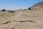
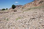
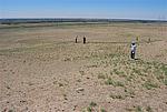
НсЙЙЬиЕуМАЙЙжўЗНЪНЃКИУЧНЬхЮЊШЫЙЄЛљДЁ,ОЭЕиШЁЭСКЛжўЖјГЩЃЌЕзПэЖЅеЃЌЯђЩЯЪеЗжЃЌЦЪУцГЪЬнаЮЁЃЕзПэ2-3.5УзЃЌЖЅПэ1.5-3Уз,ВаИпЮЊ0.5-1УзЁЃ
ЯжзДЃКЭСЧНЁЃИУЖЮЧНЬхзмГЄ709УзЃЌЕзПэ2-3.5УзЃЌЖЅПэЮЊ1.5-3Уз,ВаИпЮЊ0.5-1УзЃЌЦфжаБЃДцГЬЖШНЯВюЕФ501УзЃЌВюЕФ178УзЃЌЯћЪЇЕФ30УзЃЌЗжБ№еМЧНЬхзмГЄЕФ70%ЁЂ25%ЁЂ5%ЁЃЧНЬхЛљБОГЪЖЋФЯ-ЮїББзпЯђЃЌЕзПэЖЅеЃЌЦЪУцГЪЬнаЮЃЌИУЖЮЧНЬхНЈгаЗщЛ№ЬЈ1зљ,ЮЊЙЋУэ4КХЗщЛ№ЬЈЁЃ
Type:ЭСЧН Rammed earth wall
Protection Level:Юо
ЁЁ
Content:
Memo:
Other Records:
Distribution:
visit location in Tianditu Map[recommend] Distribution:
visit location in Tencent QQ Map Distribution:
visit location in Google MapDistribution:
visit location in Baidu MapNational ID:150823382101020068
Action:[
 Save in Data Basket
 ]
Picture:
Click the thumbnail to view the Big Pic. Click the Big Pic to Hide the Big Pic![Caption:ЙЋУэГЄГЧ11ЖЮ
loading images --Please wait...]()
![Caption:ЙЋУэГЄГЧ11ЖЮ
loading images --Please wait...]()
![Caption:ЙЋУэГЄГЧ11ЖЮ
loading images --Please wait...]() Photo Links
Photo Links:
ЁЁ Search ::
  Favorite/My Favorite :: Recent Changes :: :: Login