Official Name:
北汛地01号烽火台BeiXunDi01HaoFengHuoTaiOur Name:
宣化123烽火台 / XuanHua123FengHuoTai
Other Name:
/
Period:明 / Ming Dynasty 1368~1644
Location: 河北省,张家口市,宣化县,深井乡北汛地村北80米处112国道东侧的“大底煤场”院内 / HeBeiSheng,ZhangJiaKouShi,XuanHuaXian,ShenJingXiangBeiXunDiCunBei80MiChu112GuoDaoDongCeDeDaDiMeiChangYuanNei
[
Looking Local List]
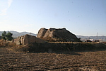
Details:长城类别:单体建筑
经纬高度:东经:114° 50′ 北纬:40° 26′ 海拔:1115
建筑形式:该烽火台,位于北汛地村北80米处,112国道东侧的“大底煤潮院内,土夯筑,方形,残高5.29米,东西长12.61米,南北长11.19米,南有门,已塌坏,成大豁状。台子北半部分已被煤场拆毁,仅存南半部分。
南侧围墙距台9.49米,东西墙距台7.87米,墙外高1.79米,内高1.14米,残厚0.8米,西侧、北侧围墙已不存。
台东、南两侧为玉米地,北侧为煤场,西侧紧傍112国道。该烽火台平面呈矩形,剖面呈梯形。
建筑方位:无
材料:夯土
附近遗存:距南面北庄子村01号烽火台1200米。
Type:烽火台 Beacon Tower
Protection Level:省保
Content:
Memo:
Other Records:
Distribution:
visit location in Tianditu Map[recommend] Distribution:
visit location in Tencent QQ Map Distribution:
visit location in Google MapDistribution:
visit location in Baidu MapNational ID:130721353201170194
Action:[
 Save in Data Basket
 ]
Picture:
Click the thumbnail to view the Big Pic. Click the Big Pic to Hide the Big Pic![Caption:北汛地01号烽火台
loading images --Please wait...]() Photo Links
Photo Links:
 Search ::
  Favorite/My Favorite :: Recent Changes :: :: Login