Official Name:
РЎҝЪЙҪПХ2¶ОXiaoKouShanXian2DuanOur Name:
/
Other Name:
/
Period:Гч
/ Ming Dynasty 1368~1644
Location: ёКЛаКЎ,°ЧТшКР,ҫёФ¶ПШ,ЖрөгЈәКҜГЕПзРЎҝЪҙеДП700ГЧЗаСВ№өҝЪ(ТІҪРҙуҝЪЧУ)Ц№өгЈәКҜГЕПзРЎҝЪҙеДП1.6З§ГЧОЮГы№өҝЪОчұұІа / GanSuSheng,BaiYinShi,JingYuanXian,QiDianShiMenXiangXiaoKouCunNan700MiQingYaGouKou(YeJiaoDaKouZi)ZhiDianShiMenXiangXiaoKouCunNan16QianMiWuMingGouKouXiBeiCe
ЎЎ[
Looking Local List]
Details:іӨіЗАаұрЈәЗҪМе
ЖрөгҫӯОіёЯ¶ИЈә¶«ҫӯЈә104Ўг 18Ўд ұұОіЈә37Ўг 02Ўд әЈ°ОЈә1334
ЦХөгҫӯОіёЯ¶ИЈә¶«ҫӯЈә104Ўг 19Ўд ұұОіЈә37Ўг 01Ўд әЈ°ОЈә1371
ЗҪМеЧЯПтЈәСШ»ЖәУ°¶·ЦІјөДёЯЙҪОӘЦчПЯЈ¬ЧЬМеОӘОчұұ-¶«ДПЧЯПтЎЈ
ЗҪМеАаұрЈәЙҪПХ
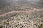
Ҫб№№МШөгј°№№Цю·ҪКҪЈәёГ¶ООӘ¶ёЗНөД»ЖәУ°¶ұЯөДёЯЙҪЈ¬БўГжЖВ¶ИФЪ65Ўг-85ЎгЦ®јдЈ¬ІўТФМПМПөД»ЖәУМмПХОӘЧЬМе·АУщМеПөЎЈ
ёГ¶ОЙҪПХЖрЧФөЪ0071өгЈ¬Ц№УЪөЪ0072өгЈ¬И«іӨ1070ГЧЎЈ
Хв¶ОЙҪПХТФ»ЖәУ°¶ұЯөДТ»ЧщёЯЙҪСВұЪәНРЪУҝөД»ЖәУЧцОӘ·АУщөДМеПөЈ¬ДПТАБ¬ГаөДЙҪВцЈ¬ұұБЩ»ЖәУЈ¬әУГжҝнФј250ГЧ-300ГЧЈ¬Йо50ГЧ-80ГЧЈ¬ЧоёЯәЈ°О1564ГЧЈ¬Ул»ЖәУәУГжөДПа¶ФёЯ¶ИФЪ250ГЧ-350ГЧЈ¬јУЦ®УР»ЖәУөДЧиёфЈ¬іӨіЗАыУГБЛХвТ»МмИ»өДЖБХПЈ¬Ҫ«өРИЛЧиУЪ»ЖәУТФұұЈ¬ФЪЙҪ¶ҘөДЦЖёЯөгЙПҪЁ·й»рМЁЈ¬УГУЪҙ«өЭРЕПўЎЈ
УлЖдЛыПа№ШЗҪМеәНТЕҙжөДЖҪГжО»ЦГ№ШПөЈәОчұұУлРЎҝЪіӨіЗ1¶ОПаҪУЈ¬¶«ДПУлРЎҝЪіӨіЗ2¶ОБ¬ҪУЎЈ
ПЦЧҙЈә
Type:ЙҪПХ Precipitous mountain areas
Protection Level:ЎЎ
Content:
Memo:
Other Records:
Distribution:
visit location in Tianditu Map[recommend] Distribution:
visit location in Tencent QQ Map Distribution:
visit location in Google MapDistribution:
visit location in Baidu MapNational ID:620421382106170017
Action:[
 Save in Data Basket
 ]
Picture:
Click the thumbnail to view the Big Pic. Click the Big Pic to Hide the Big Pic![Caption:РЎҝЪЙҪПХ2¶О
loading images --Please wait...]() Photo Links
Photo Links:
ЎЎ Search ::
  Favorite/My Favorite :: Recent Changes :: :: Login