Official Name:
黄湾山险HuangWanShanXianOur Name:
/
Other Name:
/
Period:明
/ Ming Dynasty 1368~1644
Location: 甘肃省,白银市,平川区,起点:水泉镇野麻村空心楼自然村东50米的柳沟口南侧沟沿止点:水泉镇黄湾下村东北1.50千米的水泉沙河西岸山顶 / GanSuSheng,BaiYinShi,PingChuanQu,QiDianShuiQuanZhenYeMaCunKongXinLouZiRanCunDong50MiDeLiuGouKouNanCeGouYanZhiDianShuiQuanZhenHuangWanXiaCunDongBei150QianMiDeShuiQuanShaHeXiAnShanDing
[
Looking Local List]
Details:长城类别:墙体
起点经纬高度:东经:104° 31′ 北纬:36° 51′ 海拔:1369
终点经纬高度:东经:104° 37′ 北纬:36° 49′ 海拔:1516
墙体走向:
墙体类别:山险
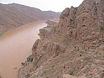
结构特点及构筑方式:山险位于黄河东岸连绵不断的群山陡壁之间,山体坡度一般在600-700之间。
该段山险起自第0004点,止于第0041点,全长9400米。
山险沿蜿蜒曲折的黄河而行,经墩墩梁、独浪沟、大坝泥、吊沟、撞水崖、鹰窝咀,遂大拐弯经过园洞闸、锈沙坪至宽沙河。沿线山势特别陡峻,山体岩石裸露,形成悬崖峭壁,沟壑纵横,地形十分复杂多变。其间有烽火台相连,与自然山体构成防御线。
现状:
Type:山险 Precipitous mountain areas
Protection Level:
Content:
Memo:
Other Records:
Distribution:
visit location in Tianditu Map[recommend] Distribution:
visit location in Tencent QQ Map Distribution:
visit location in Google MapDistribution:
visit location in Baidu MapNational ID:620403382106170002
Action:[
 Save in Data Basket
 ]
Picture:
Click the thumbnail to view the Big Pic. Click the Big Pic to Hide the Big Pic![Caption:黄湾山险
loading images --Please wait...]()
![Caption:黄湾山险
loading images --Please wait...]()
![Caption:黄湾山险
loading images --Please wait...]() Photo Links
Photo Links:
 Search ::
  Favorite/My Favorite :: Recent Changes :: :: Login