Official Name:
¥σΧ≤…Ϋœ’1ΕΈDaTanShanXian1DuanOur Name:
/
Other Name:
/
Period:Ος
/ Ming Dynasty 1368~1644
Location: Η Υύ Γ,άΦ÷ί –,ΈςΙΧ«χ,ΤπΒψΘΚΈςΙΧ«χΚ”ΩΎœγ¥σΧ≤¥εάœ“·ΟμΕΪΡœ‘Φ2«ßΟΉ÷ΙΒψΘΚΈςΙΧ«χΚ”ΩΎœγ¥σΧ≤¥εάœ“·ΟμΕΪ±±‘Φ500ΟΉ / GanSuSheng,LanZhouShi,XiGuQu,QiDianXiGuQuHeKouXiangDaTanCunLaoYeMiaoDongNanYue2QianMiZhiDianXiGuQuHeKouXiangDaTanCunLaoYeMiaoDongBeiYue500Mi
ΓΓ[
Looking Local List]
Details:≥Λ≥«άύ±πΘΚ«ΫΧε
ΤπΒψΨ≠Έ≥ΗΏΕ»ΘΚΕΪΨ≠ΘΚ103Γψ 33Γδ ±±Έ≥ΘΚ36Γψ 12Γδ ΚΘΑΈΘΚ1718
÷’ΒψΨ≠Έ≥ΗΏΕ»ΘΚΕΪΨ≠ΘΚ103Γψ 33Γδ ±±Έ≥ΘΚ36Γψ 12Γδ ΚΘΑΈΘΚ1807
«ΫΧεΉΏœρΘΚ“‘¥σΧ≤¥εΕΪ±±ΒΡάœ“·…ΫΕΗ«ΆΒΡ…Ϋ―“«Ά±ΎΘ§ΡΎ≤ύ”÷”–ΤπΖϋΝ§ΟύΒΡΗΏ…ΫΉηΒ≤Θ§Ή‘»Μ≥ Χλ»ΜΤΝ’œΘ§…ΫΫ≈±ΏΒΡΝΫΕΥ”–ΚΜΆΝ«ΫΧεΝ§Ϋ”Θ§ΉήΧεΉΏœρ”…ΕΪΡœœρΈς±±―”…λΓΘ
«ΫΧεάύ±πΘΚ…Ϋœ’
ΫαΙΙΧΊΒψΦΑΙΙ÷ΰΖΫ ΫΘΚΗΟΕΈ“‘ΕΗ«ΆΒΡΗΏ…Ϋ―¬±ΎΈΣΧλœ’Θ§ΝΔΟφΤ¬Ε»‘Ύ65Γψ-85Γψ÷°ΦδΘ§œύΕ‘ΗΏΕ»‘Ύ170ΟΉ-250ΟΉ÷°ΦδΘ§ΚΘΑΈ1718ΟΉ-1976ΟΉΓΘ
ΗΟΕΈ…Ϋœ’ΤπΉ‘ΒΎ0013ΒψΘ§÷Ι”ΎΒΎ0015ΒψΘ§»Ϊ≥Λ1660ΟΉΓΘ
’βΕΈ…Ϋœ’“‘άœ“·…ΫΒΡΗΏΨΰΕΗ«Ά―“ ·―¬±ΎΉωΈΣ’ϊΧεΒΡΖά”υΧεœΒΘ§±±“άΝ§ΟύΒΡ…Ϋ¬ωΘ§ΉνΗΏΒψάœ“·…ΫΖιΜπΧ®ΚΘΑΈ1976ΟΉΘ§ΕΗ«ΆΒΡ―¬±Ύ…œ―“ ·Βΰα÷ΓΔαΉαΨΥ ÷≈Θ§―¬±ΎΕΗ÷±Θ§≈ ≈άΦΪΡ―Θ§≥Λ≥«άϊ”ΟΝΥ’β“ΜΧλ»ΜΒΡΤΝ’œΘ§ΫΪΒ–»ΥΉη”Ύάœ“·…Ϋ“‘±±ΓΘ
œ÷Ή¥ΘΚ’βΕΈ…Ϋœ’άϊ”Οάœ“·…ΫΕΗ«Ά―¬±ΎΘ§―¬±Ύ±μΟφΈόΟςœ‘ΒΡ≤υœςΚέΦΘΘ§Χλ»Μ–Έ≥…ΒΡ―“ ·…ΫΘ§―“±Ύ÷±ΝΔΕΗ«ΆΘ§ΗΏ…Ϋ–έ÷≈Θ§≥ Χλ»ΜΒΡΤΝ’œΓΘ
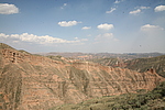
Type:…Ϋœ’ Precipitous mountain areas
Protection Level:ΓΓ
Content:
Memo:
Other Records:
Distribution:
visit location in Tianditu Map[recommend] Distribution:
visit location in Tencent QQ Map Distribution:
visit location in Google MapDistribution:
visit location in Baidu MapNational ID:620104382106170004
Action:[
 Save in Data Basket
 ]
Picture:
Click the thumbnail to view the Big Pic. Click the Big Pic to Hide the Big Pic![Caption:¥σΧ≤…Ϋœ’1ΕΈ
loading images --Please wait...]() Photo Links
Photo Links:
ΓΓ Search ::
  Favorite/My Favorite :: Recent Changes :: :: Login